My neighbors and I mow our grass on Thursday as a rule. I didn't start the rule. I'm pretty sure Steve started it. On my street, on my side of the street, there are 3 houses. One house is catty cornered and faces the street perpendicular to our street. Then Steve and I have houses on our side of the street. There were 2 other houses on our street but they've been returned to woodland. Those two houses were flooded during Hurricane Floyd, repaired and the family moved back in. Then, those families took the payout and their restored houses were torn down.
So, I go out to mow the grass and put my phone in my pocket. I can see there are some storm clouds far off, but where I'm at, it's gorgeous sunshine. I finish mowing the backyard. I stop the mower and check my phone. Not my normal behavior...just checking the weather. There is a message (again it's bright beautiful sunshine) and the message is 'Tornado WARNING for Nash County" OMG! Are you kidding. I'm sitting on the lawn mower and everything looks fine, but miles away a tornado is heading this way.
I put the mower away and take my butt in the house.
To say I was blown away...well in my mind, was true. Thank GOD I got inside before any bad weather actually came our way. It went north of me if I remember correctly.
Saturday, October 7, 2017

1983 England - the Logistics 7/9/1983 to 9/18/1983
London England - Studied Drug and Alcohol Abuse Course. 6 wonderful weeks!!!

July 9th thru August 18th
Mark Mitchell sent me a post card from Paris. We left early that morning (6:00 am) and they left later in the day for Paris.
> Wimbledon was June 20th thru July 3rd.
University of London - Chelsea College - Hortensia Road
London UK
Many blogs have been created on this site with my memories and wikipedia articles. I'm going back. It's just a matter of time. It's been 34 years (2017) and its way past time to go back.


July 9th thru August 18th
Mark Mitchell sent me a post card from Paris. We left early that morning (6:00 am) and they left later in the day for Paris.
> Wimbledon was June 20th thru July 3rd.
University of London - Chelsea College - Hortensia Road
London UK
Many blogs have been created on this site with my memories and wikipedia articles. I'm going back. It's just a matter of time. It's been 34 years (2017) and its way past time to go back.

Friday, October 6, 2017
2005 Jan 19 - Frozen - The Ice Storm

I was working in Wilson (IT job) in 2005. I was working in the Diestributed Test Lab, testing packages, antivirus, hardware, operating systems, applications, wrappers (wrap around applications to distribute them), etc. There were about 10 of us who 'resided' in the lab. We'd given up our desks in cube world. It was always cold in there as this is where the test servers were housed. There wasn't a separate room to wall them off from the humans...and most days it was 57 to 60 degrees. Every season the same.
I was working and the weather took a turn for the worse. It started sleeting. After about 10 minutes, one of my co-workers looked out the window and told me I should go home. I live in the next town north of Wilson (Rocky Mount), what is usually a 30 minute drive. I stayed until I finished testing what I was working on. Within minutes I receive a call from my daughters school. They are closing the school in the next half hour and she must be picked up. I leave and head home. I couldn't drive faster than 5 miles per hour. I was on Airport Rd and watching cars coming in my direction just spinning on the ice. I was terrified. Every inch of that drive that day was white knuckled, near crying. I had called Gregg and told him the school was closing and no way would I get there in time to pick our daughter up. He was working with an Ambulance crew taking old folks to the hospital for doctor appointments. He had to go to the school and pick her up and have her scrunch down so she wouldn't be seen in the front seat. He took her to the hospital and when he went inside to deliver the patient, he again had her scrunch down so she wasn't seen at the hospital. he could have gotten in trouble.

My drive was Forrest Hills Rd to Raleigh Rd, then Raleigh Rd to Airport Drive. Turning left on Highway 58 and taking that to Hwy 97. Once on Highway 97 it was a straight drive to my neighborhood. Unfortunately there is this killer curve where W Tarboro Rd intersects and it's a known (not to me at the time) problem. There is a steep grave from W. Tarboro down to the ditch on Hwy 97. I had to drive my tires on the passenger side up on the grass (even though it was frozen) to keep enough traction to not end up in the ditch on top of the cars that were in the ditch. I watched a man standing at the top of Hwy 97 and W Tarboro, directing a car out to go west. And it went and slid right into the ditch behind the line of cars already there. Then - HE WAS DIRECTING ME TO STOP AND DIRECTING THE NEXT CAR TO PULL IN (which would have hit the last car in the ditch. I looked at him, beeped and shook my head NO I was not stopping and I was not moving down on Hwy 97 so I could slide into the westbound ditch. He moved, I continued on slowly and I made it through the intersection. Then I crept down 97 the next mile or so and into my neighborhood. I pulled into my driveway and felt like falling face first on the driveway and kissing the ice. I was home and going no where.
Soon Greg and Megan were home and we were in for the night.
Raleigh NC
Raleigh took a serious hit. The ice fell so soon, it caught everyone unaware. They let school out, put the kids on buses and then sent them home. Unfortunately the roads in Raleigh became driveways. Everyone was stopped, cars were running, ran out of gas. People were taking in strangers in their homes. Kids on school buses were taken in. Kids at school had to stay overnight. I can't imagine how scared they were without their parents.
I do remember some posts on WRAL.com where people had to go the the RDU airport and said that "We southerners were stupid and couldn't drive on ice". "They were driving 60 mph on the roads to get to the airport. Yet we southerners were all stuck on the road.
WRAL Article
RALEIGH, N.C. — A weather system that was expected to yield only flurries brought just enough snow to snarl traffic, strand 3,000 Wake students overnight at more than 50 schools and produce nightmarish commutes lasting eight or more hours.
Many area school systems, including Wake and Durham, have canceled Thursday classes.
Gov. Mike Easley declared a state of emergency in Wake County, and shelters were opened at the State Administrative Building at 116 West Jones St. and the Highway Building at South Wilmington Street
"It's a very unfortunate situation," Raleigh Mayor Charles Meeker said in an interview with WRAL's David Crabtree. "It's been a real nightmare for all of us."
Throughout central North Carolina, the snow fell from about 10:30 a.m. to 3 p.m. Person County received the most with 2 inches, Halifax County received an inch of snow and Warren County received 1½ inches. In Wake County, Cary got nearly half an inch and western Raleigh received nearly an inch.
Many area schools decided to close early, however, there are many reports from parents that their children were still at school because buses could not get to schools. Wake County schools suspended bus service at 9 p.m. Wednesday. The system estimated that about 3,000 students were stranded at 56 schools.
Buses will begin running again at 8:30 a.m. Thursday to take the stranded students home, or parents can pick up their children. The schools will serve breakfast to students.
Wake, Durham, Edgecombe, Franklin, Granville, Nash/Rocky Mount, Person, Northampton and Vance county schools will be closed Thursday. Chapel Hill-Carrboro, Johnston, Orange and Wilson county schools will operate on a two-hour delay.
The Raleigh Police Department responded to 422 motor vehicle accident calls between 11 a.m. and 9 p.m. Wednesday. Raleigh police are continuing to urge motorists not to drive unless it is absolutely necessary to do so. Those who must travel are asked to reduce their speed, increase their separation from other vehicles and allow additional distances to stop.
Raleigh police say anyone who is stranded in his or her vehicle is reminded that it is not safe to stay in a car with its engine running. Carbon monoxide poses a significant poisoning danger under such circumstances. Raleigh Police Department patrol officers are on the lookout for stranded motorists and will offer appropriate aid. Anyone who is stranded and needs assistance should call 911.
Some of the longest commutes and worst road conditions were reported on I-40, I-440, U.S. 64 East, U.S. 1 North and Durant Road.
The snow brought eastbound traffic on Interstate 40 into Raleigh to a standstill and halted travel on the city's I-440 beltline. Cars sliding on snow-covered roads caused accidents around the capital city.
The state Highway Patrol had received more than 200 reports of accidents in the area, mostly in Wake and Granville counties, from midnight until early afternoon Wednesday, said Patty McQuillan, a spokeswoman with the state Department of Crime Control and Public Safety. She said the patrol normally receives about 40 calls a day.
There were also eight reported wrecks on I-95 in Halifax, Nash and Northampton counties, though the Highway Patrol had no reports of fatalities or major injuries.
Durham police reported 150 accidents in a three-hour period early in the afternoon. Most were fender-benders with no serious injuries.
"The Highway Patrol has said the roads are extremely slick and that people should stay home or get off the roads," McQuillan said.
Colder temperatures moved in late last week. That system mixed with a disturbance in the jetstream, which brought precipitation from the Ohio Valley, said Mike Strickler, a hydrometeorologist with the weather service.
The winter weather was confined largely to the eastern part of the state. The weather service reported only a dusting in western areas, including the Triad.
"It's produced a little more just east of (Raleigh) than we anticipated," Strickler said. "A lot of systems dry up when they get east of the mountains, but this one is still cranking."
It was quite a change from last week, when temperatures reached the 70s in some areas.
Wednesday's accumulation was expected to remain through the night due to subfreezing temperatures, making for a difficult commute Thursday morning. Flurries could return Thursday, though temperatures were expected to reach about 40 degrees, the weather service said.
This weekend, the area could see more snow, but that forecast is far from certain.
On Saturday there is a chance of rain in the afternoon, possibly starting as a brief period of freezing rain or snow, the National Weather Service said.
Saturday night, there is a 50 percent chance rain, but there is a 40 percent chance of snow on Sunday morning, the weather service said.
"Saturday night we're likely to see rain developing and then late Saturday night into early Sunday morning we may see cold enough temperatures to change some of that into frozen precipitation, but it looks like amounts may be very light," said WRAL meteorologist Elizabeth Gardner.
If the area sees snow on Sunday, it will be the second consecutive Sunday. On Jan. 16, central North Carolina was surprised with a morning snow, most of which melted as soon as it hit the ground. Some areas near I-95 saw a brief accumulation
Thursday, October 5, 2017
1995 Oct 15 - Thar she blows....Hurricane Hazel
Hurricane Hazel - 15 Oct 1954

I was not even thought of when Hurricane Hazel hit North Carolina. My parents were young (Dad 15 and Mom 12)when Hazel came through Edgecombe County, N.C. My parents Hurricane for the record books was Hurricane Hazel in 1957. Several members of the family were working in the tobacco barns, putting up tobacco. It blew off roofs and caused a lot of wind damage. It nearly destroyed the southern beaches of NC. Anytime a Hurricane was mentioned, that was the one.
Newspaper Article from Rocky Mount - Way Back When (Facebook)
The Telegram published a morning edition on Saturday, October 16, 1954, with pictures and reports of Hazel's destruction:
Dwellings in Rocky Mount’s residential areas suffered heavily by the blows but the greatest destruction swept through Tobacco Town and the main business section. Losses at tobacco warehouses alone will run into hundreds of thousands of dollars. Plate glass windows and roofs on downtown stores crumbled under the blows. One side of the A & P store on Marigold Street peeled off, and plate glass windows shattered at Bulluck’s Furniture Store on Church Street; Rocky Mount Furniture and Whaley Furniture companies on Main Street; Daniels, Merit Shoe Co., Kress, Mayfair Shop and the Ricks coffee shop, all on Main. Plate glass windows also were blown out by Hazel at the following automobile dealerships: Ray Bandy’s, Griffin-Salisbury, A. C. Motors, and Thomas-Farris Motors.
Among the early victims of the damage was the large sign that hung in front of Fox’s Jewelry, and it was soon joined by numerous plate glass windows along Main Street. Practically every television aerial mounted on the buildings on Main Street, the canvas advertising screen on the building next to the Peoples Bank, a rail crossing gate arm at Nash Street and several globes from street lamps, also fell before the onslaught of the hurricane.
The entire roof of the building formerly occupied by Brewer Paint and Wallpaper Company on Howard Street was lifted and blown away; the long metal awning in front of the Evening Telegram building was twisted off; metal roofing on literally dozens of other establishments were peeled away. Streets through town were paved in green leaves, and in many places were rendered impassable by falling trees, limbs and by electric and telephone lines.
All city schools in Rocky Mount closed at 10:15 a. m. Friday at the suggestion of Civil Defense and Red Cross officials. Edgecombe County
Schools Superintendent E. D. Johnson ordered all schools in the county closed at 10:00 a. m. and warned that all students should be at their homes and all buses off the roads by noon. Nash Superintendent L. S. Inscoe advised his principals over the county at 11:00 a. m. Friday to get their students home if they could possibly do so before the force of the storm struck. He advised them to keep at the schools students who could not make it home before the winds hit.
Power lines were down over most of the city until about 10 p. m., and still some sections of the city remained blacked out during the night. Joe Flythe, city utilities director, said there were no damages at the power plant except that one door blew out. At 1:44 p. m. power plant employees pulled the city’s main switch as a safety measure. According to Flythe, "We tried to keep the current on as long as possible but it got so bad in many places we finally cut it all out…from a safety point of view." The Carolina Power & Light Company’s lights were still out way into the night. From sunset until 9 p. m., police patrolled with light only from flashlights and the rising moon.
As soon as the storm had passed, John Pierce, manager of Woolworth’s store, did a rush business selling candles. Although the store was closed, Pierce kept one of his doors open and dealt change from a cigar box. When night fell he was still at his post doing business by the light of one of his larger candles. Another business that flourished just after the storm’s exit was the gasoline trade. Most of the stations were closed since they could not pump fuel without electric power, but two stations, one at each end of town on Church Street, were dealing out gas through pumps on tank trucks.
Dwellings in Rocky Mount’s residential areas suffered heavily by the blows but the greatest destruction swept through Tobacco Town and the main business section. Losses at tobacco warehouses alone will run into hundreds of thousands of dollars. Plate glass windows and roofs on downtown stores crumbled under the blows. One side of the A & P store on Marigold Street peeled off, and plate glass windows shattered at Bulluck’s Furniture Store on Church Street; Rocky Mount Furniture and Whaley Furniture companies on Main Street; Daniels, Merit Shoe Co., Kress, Mayfair Shop and the Ricks coffee shop, all on Main. Plate glass windows also were blown out by Hazel at the following automobile dealerships: Ray Bandy’s, Griffin-Salisbury, A. C. Motors, and Thomas-Farris Motors.
Among the early victims of the damage was the large sign that hung in front of Fox’s Jewelry, and it was soon joined by numerous plate glass windows along Main Street. Practically every television aerial mounted on the buildings on Main Street, the canvas advertising screen on the building next to the Peoples Bank, a rail crossing gate arm at Nash Street and several globes from street lamps, also fell before the onslaught of the hurricane.
The entire roof of the building formerly occupied by Brewer Paint and Wallpaper Company on Howard Street was lifted and blown away; the long metal awning in front of the Evening Telegram building was twisted off; metal roofing on literally dozens of other establishments were peeled away. Streets through town were paved in green leaves, and in many places were rendered impassable by falling trees, limbs and by electric and telephone lines.
All city schools in Rocky Mount closed at 10:15 a. m. Friday at the suggestion of Civil Defense and Red Cross officials. Edgecombe County
Schools Superintendent E. D. Johnson ordered all schools in the county closed at 10:00 a. m. and warned that all students should be at their homes and all buses off the roads by noon. Nash Superintendent L. S. Inscoe advised his principals over the county at 11:00 a. m. Friday to get their students home if they could possibly do so before the force of the storm struck. He advised them to keep at the schools students who could not make it home before the winds hit.
Power lines were down over most of the city until about 10 p. m., and still some sections of the city remained blacked out during the night. Joe Flythe, city utilities director, said there were no damages at the power plant except that one door blew out. At 1:44 p. m. power plant employees pulled the city’s main switch as a safety measure. According to Flythe, "We tried to keep the current on as long as possible but it got so bad in many places we finally cut it all out…from a safety point of view." The Carolina Power & Light Company’s lights were still out way into the night. From sunset until 9 p. m., police patrolled with light only from flashlights and the rising moon.
As soon as the storm had passed, John Pierce, manager of Woolworth’s store, did a rush business selling candles. Although the store was closed, Pierce kept one of his doors open and dealt change from a cigar box. When night fell he was still at his post doing business by the light of one of his larger candles. Another business that flourished just after the storm’s exit was the gasoline trade. Most of the stations were closed since they could not pump fuel without electric power, but two stations, one at each end of town on Church Street, were dealing out gas through pumps on tank trucks.
****
Wikipedia
This article is about the Atlantic hurricane of 1954. For other storms with the same name, see Tropical Storm Hazel (disambiguation). For the Canadian politician nicknamed "Hurricane Hazel", see Hazel McCallion.
Hurricane Hazel Category 4 major hurricane
Hurricane Hazel was the deadliest and costliest hurricane of the 1954 Atlantic hurricane season. The storm killed at least 400 people in Haiti before striking the United States near the border between North and South Carolina, as a Category 4 hurricane. After causing 95 fatalities in the US, Hazel struck Canada as an extratropical storm, raising the death toll by 81 people, mostly in Toronto. As a result of the high death toll and the damage caused by Hazel, its name was retired from use for North Atlantic hurricanes.
In Haiti, Hazel destroyed 40% of the coffee trees and 50% of the cacao crop, affecting the economy for several years to come. The hurricane made landfall near Calabash, North Carolina, and destroyed most waterfront dwellings near its point of impact. From North Carolina, it traveled north along the Atlantic coast. Hazel affected Virginia, Washington, D.C., West Virginia, Maryland, Delaware, New Jersey, Pennsylvania, and New York; it brought gusts near 160 km/h (100 mph) and caused $281 million (1954 USD) in damage. When it was over Pennsylvania, Hazel consolidated with a cold front, and turned northwest towards Canada. When it hit Ontario as an extratropical storm, rivers and streams in and around Toronto overflowed their banks, which caused severe flooding. As a result, many residential areas located in the local floodplains, such as the Raymore Drive area, were subsequently converted to parkland. In Canada alone, over C$135 million (2016: $1.2 billion) of damage was incurred.
The effects of Hazel were particularly unprecedented in Toronto, due to a combination of heavy rainfall during the preceding weeks, a lack of experience in dealing with tropical storms and the storm's unexpected retention of power. Hazel had traveled 1,100 km (680 mi) over land, but while approaching Canada, it had merged with an existing powerful cold front. The storm stalled over the Greater Toronto Area, and although it was now extratropical, it remained as powerful as a category 1 hurricane. To help with the cleanup, 800 members of the military were summoned, and a Hurricane Relief Fund was established that distributed $5.1 million (2009: $41.7 million) in aid.
At the Raleigh-Durham Airport in North Carolina, gusts of 90 mph (140 km/h) were recorded; in surrounding cities, including Kinston, Goldsboro, and Faison, wind gusts were estimated to have reached 120 mph (190 km/h). With such high winds state-wide, heavy damage was caused to forests, and to property as a result of falling trees. However, since the Carolinas, like the rest of the Southeastern United States, were suffering from a severe drought, the heavy rainfall brought by Hazel was welcome. In North Carolina, the most rain was received in the interior of the state: Robbins received 286 mm (11.3 in) of rain, and Carthage received 247 mm (9.7 in).
Nineteen people were killed in North Carolina, with several hundred more injured; 15,000 homes were destroyed and another 39,000 were damaged. The number of people left homeless by the storm was "uncounted thousands". Damages in the Carolinas amounted to $163 million, with $61 million incurred by beachfront property. Total damage in the United States ranged from $281 million to $308 million.
While Hazel caused the most damage in the Carolinas, the storm did not lose all of its intensity. Going north, Hazel turned extratropical by midday when it merged with a cold front; however, it retained hurricane-strength winds and it was continuing to drop heavy rainfall
******************************
1989 Sep 9 - Thar She Blows - Hurricane Hugo
Hurricane Hugo - 1889 Sep 9
 My first ALMOST Hurricane
Hurricane Hugo was supposed to come through Rocky Mount back in the 1980s. Dad was a truck driver on the road. Mom was working at her job on 3rd shift and Paula was married.
That left me at our West Mount house to handle preparation for the storm. Dad called me before the storm, however it was almost dark. He had built the north end of the fence at the pool, but there was nothing bracing it against any winds. He told me if it wasn't braced, then it would fall over and possibly in the in ground pool. I contacted my neighbors and asked their help. There we were the 3 of us, Paul and Linda and myself taking wood and bracing that fence so it wouldn't fall. It worked. After we finished with the fence. I had to bring the truck around and use the headlights for light. I was stressed out at this point, but we managed to get it done, I profusely thanked them. I went inside and got set for a long night. I was there alone and I was worried, but I had to do what I had to do; and It was what it was. I went on to sleep and expected by 2am to be awakened to hear the storm raging. I woke up several times during the night and heard nothing more than crickets chirping (if that). At daybreak, I turned on the TV and the storm had turned westward and hit Charlotte NC full force.
Wikipedia
Hurricane Hugo was a powerful Cape Verde–type hurricane that caused widespread damage and loss of life in the Leeward Islands, Puerto Rico, and the Southeast United States. It formed over the eastern Atlantic near the Cape Verde Islands on September 9, 1989. Hugo moved thousands of miles across the Atlantic, rapidly strengthening to briefly attain category 5 hurricane strength on its journey. It later crossed over Guadeloupe and St. Croix on September 17 and 18 as a category 4 hurricane. Weakening slightly more, it passed over Puerto Rico as a strong category 3 hurricane. Further weakening occurred several hours after re-emerging into the Atlantic, becoming downgraded to a category 2 hurricane. However, it re-strengthened into a category 4 hurricane before making landfall just slightly north of Charleston, on Isle of Palms on September 21 with 140 mph sustained winds (gusts to more than 160 mph). It had devolved to a remnant low near Lake Erie by the next day. As of 2016, Hurricane Hugo is the most intense tropical cyclone to strike the East Coast north of Florida since 1900.
A Cape Verde hurricane, or Cabo Verde hurricane is an Atlantic hurricane that originates at low-latitude in the deep tropics from a tropical wave that has passed over or near the Cape Verde islands after exiting the coast of West Africa.
Hurricane Hugo caused 34 fatalities (most by electrocution or drowning) in the Caribbean and 27 in South Carolina, left nearly 100,000 homeless, and resulted in $10 billion (1989 USD) in damage overall, making it the most damaging hurricane ever recorded at the time. Of this total, $7 billion was from the United States and Puerto Rico, ranking it as the costliest storm to impact the country at the time. Since 1989, however, it has been surpassed by multiple storms and now ranks as the eleventh costliest in the United States.
******************************

Hurricane Hugo was supposed to come through Rocky Mount back in the 1980s. Dad was a truck driver on the road. Mom was working at her job on 3rd shift and Paula was married.
That left me at our West Mount house to handle preparation for the storm. Dad called me before the storm, however it was almost dark. He had built the north end of the fence at the pool, but there was nothing bracing it against any winds. He told me if it wasn't braced, then it would fall over and possibly in the in ground pool. I contacted my neighbors and asked their help. There we were the 3 of us, Paul and Linda and myself taking wood and bracing that fence so it wouldn't fall. It worked. After we finished with the fence. I had to bring the truck around and use the headlights for light. I was stressed out at this point, but we managed to get it done, I profusely thanked them. I went inside and got set for a long night. I was there alone and I was worried, but I had to do what I had to do; and It was what it was. I went on to sleep and expected by 2am to be awakened to hear the storm raging. I woke up several times during the night and heard nothing more than crickets chirping (if that). At daybreak, I turned on the TV and the storm had turned westward and hit Charlotte NC full force.
Wikipedia
Hurricane Hugo was a powerful Cape Verde–type hurricane that caused widespread damage and loss of life in the Leeward Islands, Puerto Rico, and the Southeast United States. It formed over the eastern Atlantic near the Cape Verde Islands on September 9, 1989. Hugo moved thousands of miles across the Atlantic, rapidly strengthening to briefly attain category 5 hurricane strength on its journey. It later crossed over Guadeloupe and St. Croix on September 17 and 18 as a category 4 hurricane. Weakening slightly more, it passed over Puerto Rico as a strong category 3 hurricane. Further weakening occurred several hours after re-emerging into the Atlantic, becoming downgraded to a category 2 hurricane. However, it re-strengthened into a category 4 hurricane before making landfall just slightly north of Charleston, on Isle of Palms on September 21 with 140 mph sustained winds (gusts to more than 160 mph). It had devolved to a remnant low near Lake Erie by the next day. As of 2016, Hurricane Hugo is the most intense tropical cyclone to strike the East Coast north of Florida since 1900.
A Cape Verde hurricane, or Cabo Verde hurricane is an Atlantic hurricane that originates at low-latitude in the deep tropics from a tropical wave that has passed over or near the Cape Verde islands after exiting the coast of West Africa.
Hurricane Hugo caused 34 fatalities (most by electrocution or drowning) in the Caribbean and 27 in South Carolina, left nearly 100,000 homeless, and resulted in $10 billion (1989 USD) in damage overall, making it the most damaging hurricane ever recorded at the time. Of this total, $7 billion was from the United States and Puerto Rico, ranking it as the costliest storm to impact the country at the time. Since 1989, however, it has been surpassed by multiple storms and now ranks as the eleventh costliest in the United States.
******************************
1996 Sep 6 - Thar She Blows --Hurricane Fran
Hurricane Fran = 6 Sep 1996
 Hurricane Fran:
We were living in Rocky Mount. Hurricane Fran was my first experience with hurricanes. It passed us and went full force into Raleigh NC, 45 minutes west of here.
They had trees down from the winds. Lots of trees down from the wind. Nothing prepared me for Fran. We had an emergency radio that kept broadcasting the storm as it loomed closer. Stupid me thought that it would continue to work through the storm, along with other electrical appliances. I had clothes that I'd washed (always have clothes to wash, the struggle is real). I had put them in the dryer when the storm started and the electrical went out. I took all the clothes out and hung them up.
I had the old timey oil lamps out and ready. The stove is cook-top gas and oven electric, so as long as I could use a match to start the gas stove, we could cook and eat (after the storm is over).
At the beginning of the storm, Gregg and I stood at the back door and looked at the storm. What a strange thing that is. Wind blowing, thunder through the storm was a straggled burring sound. Lightning. We didn't stand there long.
I have a very tall pine tree in my front yard, new my bedroom, and the neighbor beside us has several pine trees that were even taller near my daughters bedroom. Fran hit at night, and I was nervous about sleeping near those trees, so I put an twin mattress in the hallway and Megan and I slept there. my 3 toddler daughter was lying at the bathroom door and there were no lights. She said "I have to go potty". Of course, I am not thinking (half asleep) and say "Go Ahead". Then she cries out "I don't know where the bathroom is". So, I jump up and walk her to the potty. Bless her heart. Stress does not work well on me.
Margaret, Gregg's sister had a huge tree fall in their back yard in Wendell NC. The tree was in her back yard and when it fell, it fell right to the window. When she awoke the next morning and went to look out her kitchen window, all she saw was branches and leaves.
Gregg was working at the City at this point and had to work OT cleaning up the streets. I was able to clear our yard, there was just pine straw everywhere. Fran did very little in our yard, just pine straw and limbs down. Some damage occurred in Rocky Mount, but the brunt was definitely felt west of us.
Wikipedia
Hurricane Fran caused extensive damage in the United States in early September 1996. The sixth named storm, fifth hurricane, and fourth major hurricane of the 1996 Atlantic hurricane season, Fran developed from a tropical wave near Cape Verde on August 23. Due to nearby Hurricane Edouard, the depression remained disorganized as it tracked westward, though it eventually intensified into Tropical Storm Fran on August 27. While heading west-northwestward, Fran steadily strengthened into a hurricane on August 29, but weakened back to a tropical storm on the following day. On August 31, Fran quickly re-intensified into a hurricane. By September 2, Fran began to parallel the islands of the Bahamas and slowly curved north-northwestward. Fran peaked as a 120 mph (195 km/h) Category 3 hurricane by early on September 5. Thereafter, Fran weakened slightly, before it made landfall near Cape Fear, North Carolina early on September 6. The storm rapidly weakened inland and was only a tropical depression later that day. Eventually, Fran curved east-northeastward and transitioned into an extra tropical cyclone over Ontario early on September 9.
In Florida, high tides capsized a boat with five people aboard, though all were rescued. No significant effects were reported in Georgia. The outer bands of Fran produced high winds and light to moderate rainfall in South Carolina. As a result, numerous trees and power lines were downed, which damaged cars, left over 63,000 people without electricity. Large waves in North Carolina caused significant coastal flooding in some cities. Overall, Fran was attributed to 27 fatalities and $3.2 billion (1996 USD) in damage. Fran is also the most recent hurricane to make landfall in the Carolinas as a major hurricane.
Fran caused coastal damage from the South Carolina border to Topsail Island, North Carolina. Its 12-foot storm surge carried away a temporary North Topsail Beach police station and town hall, housed in a double-wide trailer since Hurricane Bertha's rampage across the same area in July. The Kure Beach Pier was destroyed during the storm as well. Extensive flooding struck the coast around Wrightsville Beach, just up the coast from Cape Fear. In Jacksonville, North Carolina, three schools and several homes were damaged. The storm was most damaging to the barrier islands on the North Carolina coastline.
Inland, the storm caused damage on its way north from Wilmington to Raleigh. Unexpectedly, high wind damage extended along the I-40 corridor up through Raleigh and points north and as far west as Guilford County, damaging historic buildings and trees throughout the Triangle including at North Carolina State University and the University of North Carolina[19] Classes were canceled for the day at UNC due to a state of emergency in Chapel Hill, and it was almost a week before the university's water supply was drinkable again.
Rain of up to 16 inches (406 mm) deluged interior North Carolina, Virginia and West Virginia,[20] bringing dangerous river flooding to much of the mid-Atlantic. Hurricane Fran's thrashing of North Carolina aggravated the state's problems caused by numerous weather disasters in 1996.
At least six people were killed in the Carolinas; most of them were from auto accidents and more died as a result of the shock from the damage of the storm. In North Carolina, 1.3 million people were left without power. In North Topsail Beach and Carteret County, there was over $500 million (1996 USD) in damage and 90% of structures were damaged.[21] One male teenager died from drowning caused by flooding of Crabtree Creek at Old Lassiter Mill in Raleigh. Fran also destroyed the Basketball Gym on the Campus of St. Andrews College in Laurinburg, North Carolina. Hurricane Fran also destroyed 3 piers in Surf City.

We were living in Rocky Mount. Hurricane Fran was my first experience with hurricanes. It passed us and went full force into Raleigh NC, 45 minutes west of here.
They had trees down from the winds. Lots of trees down from the wind. Nothing prepared me for Fran. We had an emergency radio that kept broadcasting the storm as it loomed closer. Stupid me thought that it would continue to work through the storm, along with other electrical appliances. I had clothes that I'd washed (always have clothes to wash, the struggle is real). I had put them in the dryer when the storm started and the electrical went out. I took all the clothes out and hung them up.
I had the old timey oil lamps out and ready. The stove is cook-top gas and oven electric, so as long as I could use a match to start the gas stove, we could cook and eat (after the storm is over).
At the beginning of the storm, Gregg and I stood at the back door and looked at the storm. What a strange thing that is. Wind blowing, thunder through the storm was a straggled burring sound. Lightning. We didn't stand there long.
I have a very tall pine tree in my front yard, new my bedroom, and the neighbor beside us has several pine trees that were even taller near my daughters bedroom. Fran hit at night, and I was nervous about sleeping near those trees, so I put an twin mattress in the hallway and Megan and I slept there. my 3 toddler daughter was lying at the bathroom door and there were no lights. She said "I have to go potty". Of course, I am not thinking (half asleep) and say "Go Ahead". Then she cries out "I don't know where the bathroom is". So, I jump up and walk her to the potty. Bless her heart. Stress does not work well on me.
Margaret, Gregg's sister had a huge tree fall in their back yard in Wendell NC. The tree was in her back yard and when it fell, it fell right to the window. When she awoke the next morning and went to look out her kitchen window, all she saw was branches and leaves.
Gregg was working at the City at this point and had to work OT cleaning up the streets. I was able to clear our yard, there was just pine straw everywhere. Fran did very little in our yard, just pine straw and limbs down. Some damage occurred in Rocky Mount, but the brunt was definitely felt west of us.
Wikipedia
Hurricane Fran caused extensive damage in the United States in early September 1996. The sixth named storm, fifth hurricane, and fourth major hurricane of the 1996 Atlantic hurricane season, Fran developed from a tropical wave near Cape Verde on August 23. Due to nearby Hurricane Edouard, the depression remained disorganized as it tracked westward, though it eventually intensified into Tropical Storm Fran on August 27. While heading west-northwestward, Fran steadily strengthened into a hurricane on August 29, but weakened back to a tropical storm on the following day. On August 31, Fran quickly re-intensified into a hurricane. By September 2, Fran began to parallel the islands of the Bahamas and slowly curved north-northwestward. Fran peaked as a 120 mph (195 km/h) Category 3 hurricane by early on September 5. Thereafter, Fran weakened slightly, before it made landfall near Cape Fear, North Carolina early on September 6. The storm rapidly weakened inland and was only a tropical depression later that day. Eventually, Fran curved east-northeastward and transitioned into an extra tropical cyclone over Ontario early on September 9.
In Florida, high tides capsized a boat with five people aboard, though all were rescued. No significant effects were reported in Georgia. The outer bands of Fran produced high winds and light to moderate rainfall in South Carolina. As a result, numerous trees and power lines were downed, which damaged cars, left over 63,000 people without electricity. Large waves in North Carolina caused significant coastal flooding in some cities. Overall, Fran was attributed to 27 fatalities and $3.2 billion (1996 USD) in damage. Fran is also the most recent hurricane to make landfall in the Carolinas as a major hurricane.
Fran caused coastal damage from the South Carolina border to Topsail Island, North Carolina. Its 12-foot storm surge carried away a temporary North Topsail Beach police station and town hall, housed in a double-wide trailer since Hurricane Bertha's rampage across the same area in July. The Kure Beach Pier was destroyed during the storm as well. Extensive flooding struck the coast around Wrightsville Beach, just up the coast from Cape Fear. In Jacksonville, North Carolina, three schools and several homes were damaged. The storm was most damaging to the barrier islands on the North Carolina coastline.
Inland, the storm caused damage on its way north from Wilmington to Raleigh. Unexpectedly, high wind damage extended along the I-40 corridor up through Raleigh and points north and as far west as Guilford County, damaging historic buildings and trees throughout the Triangle including at North Carolina State University and the University of North Carolina[19] Classes were canceled for the day at UNC due to a state of emergency in Chapel Hill, and it was almost a week before the university's water supply was drinkable again.
Rain of up to 16 inches (406 mm) deluged interior North Carolina, Virginia and West Virginia,[20] bringing dangerous river flooding to much of the mid-Atlantic. Hurricane Fran's thrashing of North Carolina aggravated the state's problems caused by numerous weather disasters in 1996.
At least six people were killed in the Carolinas; most of them were from auto accidents and more died as a result of the shock from the damage of the storm. In North Carolina, 1.3 million people were left without power. In North Topsail Beach and Carteret County, there was over $500 million (1996 USD) in damage and 90% of structures were damaged.[21] One male teenager died from drowning caused by flooding of Crabtree Creek at Old Lassiter Mill in Raleigh. Fran also destroyed the Basketball Gym on the Campus of St. Andrews College in Laurinburg, North Carolina. Hurricane Fran also destroyed 3 piers in Surf City.
Sunday, October 1, 2017
1986 Aug 17- Myrtle Beach & Hurricane Charley (Charlotte) and Gale (Gail) Force Winds
In 1986, I was hanging out with college buddy Gail P. I'd completed college and was working at a rent to own place K-Rentals, as Assistant Manager.
But at this point, on August 17th, 1987, we were headed to Myrtle Beach, SC. Gail's egg donor as she is known now was down at the beach with 2 of her friends. Gail and I were going down to spend the weekend. The most interesting thing, we were headed down as Hurricane Charley was skirting the coast. Gail drove her jeep with soft sides and roof. I remember how utilitarian the jeep felt with the metal doors that thudded when you closed them. As we got closer to the coast we could see the clouds from the hurricane north of us, the swirling pattern. It was quite scary. It was still very windy and it felt like the top of the jeep was going to come off. By the time we got to Wilmington and turned south toward Myrtle Beach, it was much better. The storm was in our rear view mirror. My nickname at that time was Charlie. It was what I used at the Canton Station to assist with writing out the tickets that we used to order food and the customers used to pay for their meals. The announcer on the radio kept talking about Hurricane Charley with Gail force winds. We made a joke out of it. There were moments in that jeep on the ride down that were disconcerting. In our own funny way, we found ourselves saying "Hurricane Charley with Gail force winds...Watch out Myrtle Beach.
We made it safely to the condo and after meeting Gail's egg donor friends, and getting settled in, we went on to sleep. We knew when we arrived at the condo, that we would be sleeping on the couch. I took the floor.


The next morning we were up and getting ready to go out to the beach. Myrtle Beach is a very busy beach. We found our places outside and just stood in the water, or sat on the chairs watching the waves. I do remember standing out in the water further out than Gail and she could see a wave getting ready to clobber me. I either ducked under or jumped up but either way I made it. All I had to see were her eyes getting bigger and bigger.
We spent some time up in the condo with the ladies also. I remember one of the friends had these cysts all over her face. She was actually digging them out. It left scars but evidently she wanted them out.
Our DM at K-Rentals had heard we were going down and gave me the key to the company condo. He said he didn't know if anyone had the condo that weekend and if we got caught there it would be on us. Nice guy eh? But, gave us the opportunity to go down and see how the rich half of that business lives.
It was a quick weekend trip but we had a great time as usual.
Hurricane Charley - August 17, 1986
https://www.weather.gov/mhx/HurricaneCharley1986Review
Overview
Hurricane Charley spawned from a trough of low pressure that persisted over south Florida and the southeast Gulf of Mexico. Showers and thunderstorms associated with this system first appeared over the Florida peninsula on August 11th, 1986. The activity spread into the eastern Gulf of Mexico the next day, when surface observations indicated a very broad area of low pressure formed. The poorly defined, diffuse system drifted north on the 12th and 13th and became better organized over the Florida panhandle and Georgia as it merged into a decaying frontal trough. Continuing to improve in organization, the low emerged off the Georgia/South Carolina coast during the morning of the 15th, when it became a tropical depression. By mid-afternoon, the depression strengthened into a tropical storm. A weak ridge north of the storm led to a slow east to northeast drift. A trough amplified west of the storm over the eastern United States, resulting in a more northerly motion on the 17th and 18th. Charley recurved more to the eastward by the 19th and weakened as it merged with a frontal zone. By the 21st, as an extratropical low, Charley significantly deepened and became a large, strong storm which migrated to Europe, and eventually dissipated in the North Sea.
Track of Hurricane Charley, August 12-18, 1986 (Courtesy National Hurricane Center)
 Impacts
Charley crossed the coast of North Carolina as a minimal hurricane, producing locally strong wind gusts, peaking at 80 mph in Frisco. Charley produced heavy amounts of rain falling along the coast, with up to 7 inches near Manteo. As Charley moved ashore, the storm produced high tides, reaching 5.78 feet at the Duck Coe Fishing Pier. A woman drowned near Cape Hatteras while attempting to drive through a flooded roadway. Roads and bridges across the Outer Banks were flooded with up to 3 feet of water, including a portion of North Carolina Highway 12 near Hatteras Island. The storm left about 8,000 people without power, but overall damage was minimal and limited to shingles and roofs. Statewide, the impact was primarily caused by tidal flooding and downed trees, and a preliminary damage estimate placed total monetary losses at $400,000 in 1986 dollars.
Satellite photograph of Hurricane Charley near peak intensity off of the North Carolina coast, August 17, 1986.

Rainfall Totals from Hurricane Charley August 12-17, 1986
(Courtesy David Roth, Weather Prediction Center)

Flooding in Ireland from Hurricane Charley, August 1986.

Interestingly, Charley continued across the Atlantic as an extratropical cyclone and became one of the strongest storms to ever effect Ireland. The counties of Dublin and Wicklow were badly hit and there was extensive damage to homes and businesses with the River Dargle and the River Dodder both overflowing their banks.
SOURCES
National Hurricane Ceneer
CASE STUDY TEAM:
Chris Collins
Wikipedia - Definition of Gale force winds:
The most common way of measuring winds is with the Beaufort scale, which defines a gale as wind from 50 to 102 km/h. It is an empirical measure for describing wind speed based mainly on observed sea conditions. Its full name is the Beaufort Wind Force Scale.
But at this point, on August 17th, 1987, we were headed to Myrtle Beach, SC. Gail's egg donor as she is known now was down at the beach with 2 of her friends. Gail and I were going down to spend the weekend. The most interesting thing, we were headed down as Hurricane Charley was skirting the coast. Gail drove her jeep with soft sides and roof. I remember how utilitarian the jeep felt with the metal doors that thudded when you closed them. As we got closer to the coast we could see the clouds from the hurricane north of us, the swirling pattern. It was quite scary. It was still very windy and it felt like the top of the jeep was going to come off. By the time we got to Wilmington and turned south toward Myrtle Beach, it was much better. The storm was in our rear view mirror. My nickname at that time was Charlie. It was what I used at the Canton Station to assist with writing out the tickets that we used to order food and the customers used to pay for their meals. The announcer on the radio kept talking about Hurricane Charley with Gail force winds. We made a joke out of it. There were moments in that jeep on the ride down that were disconcerting. In our own funny way, we found ourselves saying "Hurricane Charley with Gail force winds...Watch out Myrtle Beach.
We made it safely to the condo and after meeting Gail's egg donor friends, and getting settled in, we went on to sleep. We knew when we arrived at the condo, that we would be sleeping on the couch. I took the floor.


The next morning we were up and getting ready to go out to the beach. Myrtle Beach is a very busy beach. We found our places outside and just stood in the water, or sat on the chairs watching the waves. I do remember standing out in the water further out than Gail and she could see a wave getting ready to clobber me. I either ducked under or jumped up but either way I made it. All I had to see were her eyes getting bigger and bigger.
We spent some time up in the condo with the ladies also. I remember one of the friends had these cysts all over her face. She was actually digging them out. It left scars but evidently she wanted them out.
Our DM at K-Rentals had heard we were going down and gave me the key to the company condo. He said he didn't know if anyone had the condo that weekend and if we got caught there it would be on us. Nice guy eh? But, gave us the opportunity to go down and see how the rich half of that business lives.
It was a quick weekend trip but we had a great time as usual.
Hurricane Charley - August 17, 1986
https://www.weather.gov/mhx/HurricaneCharley1986Review
Overview
Hurricane Charley spawned from a trough of low pressure that persisted over south Florida and the southeast Gulf of Mexico. Showers and thunderstorms associated with this system first appeared over the Florida peninsula on August 11th, 1986. The activity spread into the eastern Gulf of Mexico the next day, when surface observations indicated a very broad area of low pressure formed. The poorly defined, diffuse system drifted north on the 12th and 13th and became better organized over the Florida panhandle and Georgia as it merged into a decaying frontal trough. Continuing to improve in organization, the low emerged off the Georgia/South Carolina coast during the morning of the 15th, when it became a tropical depression. By mid-afternoon, the depression strengthened into a tropical storm. A weak ridge north of the storm led to a slow east to northeast drift. A trough amplified west of the storm over the eastern United States, resulting in a more northerly motion on the 17th and 18th. Charley recurved more to the eastward by the 19th and weakened as it merged with a frontal zone. By the 21st, as an extratropical low, Charley significantly deepened and became a large, strong storm which migrated to Europe, and eventually dissipated in the North Sea.
Track of Hurricane Charley, August 12-18, 1986 (Courtesy National Hurricane Center)

Charley crossed the coast of North Carolina as a minimal hurricane, producing locally strong wind gusts, peaking at 80 mph in Frisco. Charley produced heavy amounts of rain falling along the coast, with up to 7 inches near Manteo. As Charley moved ashore, the storm produced high tides, reaching 5.78 feet at the Duck Coe Fishing Pier. A woman drowned near Cape Hatteras while attempting to drive through a flooded roadway. Roads and bridges across the Outer Banks were flooded with up to 3 feet of water, including a portion of North Carolina Highway 12 near Hatteras Island. The storm left about 8,000 people without power, but overall damage was minimal and limited to shingles and roofs. Statewide, the impact was primarily caused by tidal flooding and downed trees, and a preliminary damage estimate placed total monetary losses at $400,000 in 1986 dollars.
Satellite photograph of Hurricane Charley near peak intensity off of the North Carolina coast, August 17, 1986.

Rainfall Totals from Hurricane Charley August 12-17, 1986
(Courtesy David Roth, Weather Prediction Center)

Flooding in Ireland from Hurricane Charley, August 1986.
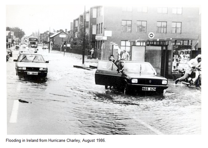
Interestingly, Charley continued across the Atlantic as an extratropical cyclone and became one of the strongest storms to ever effect Ireland. The counties of Dublin and Wicklow were badly hit and there was extensive damage to homes and businesses with the River Dargle and the River Dodder both overflowing their banks.
SOURCES
National Hurricane Ceneer
CASE STUDY TEAM:
Chris Collins
Wikipedia - Definition of Gale force winds:
The most common way of measuring winds is with the Beaufort scale, which defines a gale as wind from 50 to 102 km/h. It is an empirical measure for describing wind speed based mainly on observed sea conditions. Its full name is the Beaufort Wind Force Scale.
Subscribe to:
Posts (Atom)